
Ficheiro:Qin empire 210 BCE.jpg
Qin_empire_210_BCE.jpg (555 × 545 píxeis, tamanho: 298 kB, tipo MIME: image/jpeg)
Descrição do ficheiro
From english Wikipedia:
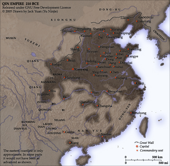
As part of his unification of China in 221 BC, Qin Shi Huang divided his empire into thirty six commanderies, each subdivided into an number of counties. The significance of the administrative reforms was its introduction of a uniformly centralised system of imperial control. The system was followed by the Han Dynasty, though with a certain degree of compromise. Thereafter, the system became the norm for later dynasties and eventually evolved into the present administrative structure of Mainland China. See: Political divisions of China.
The location of the Yellow River and commandery seats follows Tan Qixiang (ed.), Zhongguo lishi ditu (中国历史地图集), 1982. Note that the Yellow River is considerably to the north of its present flow.
The coloured territories show the approximate extent of Qin political control at the death of Qin Shi Huang in 210 BC. At that time more commanderies were added to the original thirty six, and these are also shown on the map.
Created and copyright (2005) by Yu Ninjie. Released under the GNU Free Documentation License.
Licenciamento

|
É concedida permissão para copiar, distribuir e/ou modificar este documento nos termos da Licença de Documentação Livre GNU, versão 1.2 ou qualquer versão posterior publicada pela Free Software Foundation; sem Secções Invariantes, sem textos de Capa e sem textos de Contra-Capa. É incluída uma cópia da licença na secção intitulada GNU Free Documentation License. |
| A utilização deste ficheiro é regulada nos termos da licença Creative Commons - Atribuição-CompartilhaIgual 3.0 Não Adaptada. | ||
| ||
| Esta marca de licenciamento foi adicionada a este ficheiro durante a atualização da licença GFDL. |
Histórico do ficheiro
Clique uma data e hora para ver o ficheiro tal como ele se encontrava nessa altura.
| Data e hora | Miniatura | Dimensões | Utilizador | Comentário | |
|---|---|---|---|---|---|
| atual | 17h08min de 2 de setembro de 2005 | | 555 × 545 (298 kB) | David.gaya | From english Wikipedia: As part of his unification of China in 221 BC, Qin Shi Huang divided his empire into thirty six commanderies, each subdivided into an number of counties. The significance of the administrative reforms wa |
Utilização local do ficheiro
As seguintes 2 páginas usam este ficheiro:
Utilização global do ficheiro
As seguintes wikis usam este ficheiro:
- Uso no domínio als.wikipedia.org
- Uso no domínio ar.wikipedia.org
- Uso no domínio azb.wikipedia.org
- Uso no domínio ba.wikipedia.org
- Uso no domínio be.wikipedia.org
- Uso no domínio bn.wikipedia.org
- Uso no domínio ce.wikipedia.org
- Uso no domínio de.wikipedia.org
- Uso no domínio el.wikipedia.org
- Uso no domínio en.wikipedia.org
- Uso no domínio en.wikiversity.org
- Uso no domínio es.wikipedia.org
- Uso no domínio et.wikipedia.org
- Uso no domínio fi.wikipedia.org
- Uso no domínio fi.wikibooks.org
- Uso no domínio frr.wikipedia.org
- Uso no domínio fr.wikipedia.org
- Uso no domínio fr.wikiversity.org
- Uso no domínio he.wikipedia.org
- Uso no domínio hu.wikipedia.org
- Uso no domínio hy.wikipedia.org
- Uso no domínio id.wikipedia.org
- Uso no domínio kk.wikipedia.org
- Uso no domínio ko.wikipedia.org
- Uso no domínio la.wikipedia.org
- Uso no domínio lt.wikipedia.org
- Uso no domínio ml.wikipedia.org
- Uso no domínio nl.wikipedia.org
- Uso no domínio nn.wikipedia.org
- Uso no domínio no.wikipedia.org
- Uso no domínio pnb.wikipedia.org
- Uso no domínio ro.wikipedia.org
- Uso no domínio ru.wikipedia.org
Ver mais utilizações globais deste ficheiro.